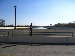
"Water is the most political thing on earth."
David Waggonner
Sunday, February 22, 2009
Friday, February 20, 2009
Thursday, February 19, 2009
NOLA study areas

This map represents the convergence of individual work the studio did following our NOLA field trip. We have narrowed our collective focus to the area surrounding two adjusted transects that run lake to river, including certain spacial and infrastructural connections between them:
1) London Avenue Canal/Elysian Fields
2) 17th Street Canal/Washington Ave Canal/MLK
(connections include Bayou St. John, City Park, the Lafitte Corridor, Jefferson Davis, I-10, and the railroad)
Six groups will study specific aspects of the existing condition in these regions:
1) residential case studies (housing typologies throughout the study area)
2) infrastructure moments (highway, canal, railroad crossings)
3) bottom of the bowl trends (relationships between three adjacent neighborhoods)
4) "blue/green" connections (connective tissue between the transects, see map)
5) surface trends (resettlement patterns, vacant land, etc)
6) physical sections (spaced along transects)
These groups will present their research at the mid review on Monday, March 2, in addition to documentation of all previous Wash U and Toronto work.
Sunday, February 15, 2009
Repopulation
For anyone interested in population return, this is a great site with block level information about what households were actively receiving mail in June 2005 and then in September 2008 (there is a really good explanation of the data on the side bar). It also has block level information about what households have received the Road Home Options 1, 2, and 3. Apparently there is address level information (which is what I'm after), but the site says you have to purchase it from a list company called Valassis.
http://www.gnocdc.org/repopulation/index.html
The main GNOCDC site (http://www.gnocdc.org/index.html) also has a lot more information that I haven't sifted through yet, but it looks pretty promising. Unfortunately, one of the data request options on the site specifically says they won't answer requests from students...
http://www.gnocdc.org/repopulation/index.html

The main GNOCDC site (http://www.gnocdc.org/index.html) also has a lot more information that I haven't sifted through yet, but it looks pretty promising. Unfortunately, one of the data request options on the site specifically says they won't answer requests from students...
Wednesday, February 11, 2009
Rainwater Path; Waterway Edge Conditions
Monday, February 9, 2009
Bayou St. John Group Analysis
Eric Soifer ~ River to Lake Site Analysis
The River to Lake site analysis can be found at the link below.
17th Street Canal to Algiers Point
Map of the route John and I walked and documented.
Basemap courtesy Waggonner & Ball Architects

Sketches showing typical sections through an exposed canal and its surroundings.

How the canal interfaces with the infrastructure of the city.

Close up of a major intersection of infrastructure (17th street canal, underground canals, I-10, the railroad, pumping station 6 and the I-10 pumping station)

Aerial view of the drainage pip es and highway interacting with the canal.
Panorama showing the canal, drainage pipes, and highway.

Panorama showing the canal, pumping station 6, and the railroad.

Panorama showing the canal-levee condition and an open corridor from a residential street to the canal.

Basemap courtesy Waggonner & Ball Architects

Sketches showing typical sections through an exposed canal and its surroundings.

How the canal interfaces with the infrastructure of the city.

Close up of a major intersection of infrastructure (17th street canal, underground canals, I-10, the railroad, pumping station 6 and the I-10 pumping station)

Aerial view of the drainage pip
 es and highway interacting with the canal.
Panorama showing the canal, drainage pipes, and highway.

Panorama showing the canal, pumping station 6, and the railroad.

Panorama showing the canal-levee condition and an open corridor from a residential street to the canal.

Riverfront/Jackson Square work
Stubborn Resilience
1.29.09
A frustrated street performer outside Cafe du Monde speaks for himself and, subconsciously, for the city, expressing a stubborn resilience that is simultaneously the best hope for and greatest threat to the future of NOLA:
"You can't ignore me away. I'm not going anywhere."
A frustrated street performer outside Cafe du Monde speaks for himself and, subconsciously, for the city, expressing a stubborn resilience that is simultaneously the best hope for and greatest threat to the future of NOLA:
"You can't ignore me away. I'm not going anywhere."
Saturday, February 7, 2009
Subscribe to:
Posts (Atom)


